


ventron kruth

basyl
User
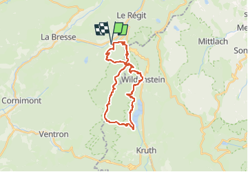

Length
26 km

Max alt
1194 m

Uphill gradient
1551 m
Km-Effort
47 km

Min alt
562 m

Downhill gradient
1549 m
Boucle
Yes
Creation date :
2025-08-01 06:32:05.585
Updated on :
2025-08-01 06:32:07.929
5h00
Difficulty : Very easy

FREE GPS app for hiking
 SityTrail
IGN / Geographical institutes
SityTrail Plus
The world is yours!
About
Trail Trail of 26 km to be discovered at Grand Est, Vosges, La Bresse. This trail is proposed by basyl.
Positioning
Country:
France
Region :
Grand Est
Department/Province :
Vosges
Municipality :
La Bresse
Location:
Unknown
Start:(Dec)
Start:(UTM)
345596 ; 5318523 (32U) N.
Comments